We need a better road.” A young, drained Dr. John L. D. Roberts reflected on his ordeal. He had run on pure adrenaline for three days straight. Finally, he had finished treating the last of his patients. There was nothing he could do for the dead. Through his exhaustion, Doc Roberts recognized that a better road would have helped his efforts, and perhaps saved lives.
Born in 1862, John Lorenzo Dow Roberts arrived on the Monterey Peninsula in 1886 with a new medical degree and a silver dollar in his pocket. A native of New York, Roberts had recently graduated fifth in his class at New York University Medical School. David Houghton, Roberts’ uncle, had suggested the Monterey region as one offering opportunity for a young physician. Houghton owned a 160-acre ranch in what is now Seaside. Soon after his arrival, the entrepreneurial Roberts offered his uncle $5,000 for the ranch, on the condition that he could turn it into a townsite to rival Pacific Grove. Terms agreed to, Roberts proceeded to divide the ranch into lots, and began selling them. In six months, Roberts paid his uncle, had $3,000 in the bank, and had 1,000 lots left to sell. Thus Seaside was born.
For Roberts, the three days of chaos began shortly after midnight on April 23, 1894, in Seaside, with shouting and a loud rap on the door. A man from Big Sur had arrived on horseback. The man told Roberts about the wreck of the steamship Los Angeles on rocks near Point Sur Lightstation, and of many injured passengers. Roberts regularly made house calls in Big Sur and was well-known to residents. Roberts gathered his instruments and supplies. He loaded them on his two-wheel cart, attached his horse and headed south. Soon after summiting Carmel Hill, Roberts was on the Old Coast Road, a crude and winding dirt road, “crooked as a Ram’s horn,” he later recalled. The pair moved at top speed, and the horse began to tire. When Roberts reached Doud Ranch near present-day Garrapata, Tom Doud met him on the road in the dark. Doud proclaimed, “Doc, your horse will never make it, she’s starting to foam. Let’s switch in my stallion. Let him run—he knows the way.” The horses were switched, the stallion ran on following the twisting road, and Roberts arrived at the wreck site before sunrise. From Seaside, the 30-mile trip took three and a half hours, the fastest time by horse and cart ever recorded.
On a small beach at the foot of Point Sur rock, Roberts took stock of the grim scene. All told, 150 passengers were on board the steamship. Many were “thrashing about in the breakers, scrambling up rocks, or lying injured or dying on the beach.” Scores of passengers had sustained serious traumatic injuries, varying from broken bones to major lacerations. Roberts worked uninterrupted for three days and nights, tending to the injured as best he could. Despite his best efforts, six passengers died. A nearby barn was repurposed as a make-shift morgue, where Roberts embalmed the dead. Roberts’ efforts were hampered by the Old Coast Road, which made difficult getting additional personnel, equipment and supplies in, and the injured out. Recognizing this deficiency, a steely determination began to set in. Roberts would champion getting a better road built.
Back on the Monterey Peninsula, Roberts talked with others about the need for a better road. He found a friend in attorney Frank Powers, cofounder of Carmel-by-the-Sea. In 1897, the two men hiked the Big Sur coast together, scouting out a route for a future road. Roberts sketched and took notes, and Powers took stereopticon photographs, which he later colorized. After the pair reached San Simeon, they returned home on a ship.
Roberts had many irons in the fire in addition to doctoring and founding Seaside. In 1890, he established the Seaside Post Office, where he and his wife Edith served as postmasters for 42 years. In 1892, Roberts was elected to the Monterey School Board, where he served for 36 years. In 1902, Roberts successfully fought to create the Presidio of Monterey for recuperating soldiers. In 1906, Roberts was elected to the Monterey County Board of Supervisors, where he served for 20 years. Despite all of these obligations and others, Rob-erts continued to vigorously pitch the idea of a coastal highway, and never gave up on his vision.
In 1915, Senator Elmer S. Rigdon of San Luis Obispo became interested in the project and arranged for Roberts to address a joint session of the California Legislature. Aided by Powers’ stereopticon images, which were projected upon a bedsheet, Roberts argued forcefully in favor of the road, both as a public safety necessity, and to open the beauty of Big Sur to the public at large. The Legislature was swayed, but there was one hitch—the State had funded some commercial roads to enable trucking via bond issuance, and the proposed road would not be commercial. A workaround was found: The road could be funded for defensive purposes. The Third Bond Act was approved by voters in 1919 which included funding for Legislative Route Number (LRN) 56—today’s Big Sur Coast Highway. Lester Gibson, an engineer for the California Highway Department, surveyed the route via pack train in preparation for work. LRN 56 was subsequently lengthened north, up to Fortuna.
Work commenced on the highway in 1921, when a contractor began working north from San Simeon. By the end of 1924, road for this segment was complete to Big Creek Canyon. In 1922, a second contractor began work on a segment between Andersen Canyon and Big Sur. This work was also complete by the end of 1924. No bridges were built. Available funds had been spent. Governor Richardson felt the State could not afford to continue funding the project. Highway work ceased at the end of 1924.
In March of 1928, convict labor was applied to the problem and work resumed. San Quentin State Prison set up three temporary labor camps housing a few hundred unskilled prisoners. The convict labor camps were moved as portions of the project were completed. By the end of 1931, the great majority of road work was complete, and work on the northern bridges had commenced. Granite Canyon, Rocky Creek and Bixby Creek Bridges were all completed in 1932. By the end of 1932, one could drive from Carmel to Big Sur on a new oiled stone (macadam) highway.
In 1933, the project gained significant capital infusion when the U.S. Congress passed the National Industrial Recovery Act during the Great Depression. Between 1933 and 1937, work focused on completing the southern bridges and a small section of road near Lopez Point. Almost two dozen bridges were built during this phase, including the Big Creek Bridge. In all, 29 bridges were required to create the Big Sur Coast Highway.
In August 1934, the California Highways and Public Works Department announced the Sign State Routes, designating California State Highways 1 through 4. CA 1 was applied to LRN 56. On September 10, 1934, the first Sign State Route Shield was installed on Carmel Hill for CA 1. Carmelites held a large outdoor party after the installation ceremony.
Big Sur Coast Highway was initially called the Carmel-San Simeon Highway. A major ceremony was held when the route opened to vehicular traffic. On June 27, 1937, Governor Frank Merriam led a caravan north from San Simeon with stops along the way en route to Pfeiffer Park, where the main dedication ceremony was held. In attendance was Dr. John L. D. Roberts. Forty-three years had passed, but Roberts lived to see his dream become reality. The total cost of the project was approximately $10 million.
Very few guard rails were in place when the Big Sur Coast Highway opened to the public. In 1940, California contracted for 12 miles of steel guard rail and 3,649 guide posts. Additional guard rails were made out of wood. The guard rail system has been subsequently upgraded several times. Even today, there are sections without guard rails to preserve scenic values. The macadam road surface was replaced with asphalt pavement in sections during the 1940s and 1950s.
During Roberts’ lifetime (he died in 1949), he was able to enjoy the beauty and the ease of the Big Sur Coast Highway and relished the fact that the roadway he championed helped to save lives and connect communities, but never could he have imagined the magnitude of the fame the road would achieve, known the world over for its beauty.
—
The Making of the Iconic Bixby Creek Bridge
Completed in 1932, iconic Bixby Creek Bridge remains an engineering and aesthetic triumph. When the bridge was built, it was the highest and longest single-span arch bridge in the world. Yet Bixby Creek Bridge, as we know it, almost never was.
Spanning Bixby Creek represented the greatest engineering challenge in construction of the Big Sur Coast Highway. A second configuration option, involving an 890-foot tunnel and a 250-foot, up-canyon bridge, was in many ways an easier solution. However, this option was rejected by the California Division of Highways, in part to optimize the aesthetic experience for visitors. For the coast-hugging option, both metal and concrete bridge options were considered. The concrete option was chosen because it was a bit less expensive, and for aesthetic reasons.
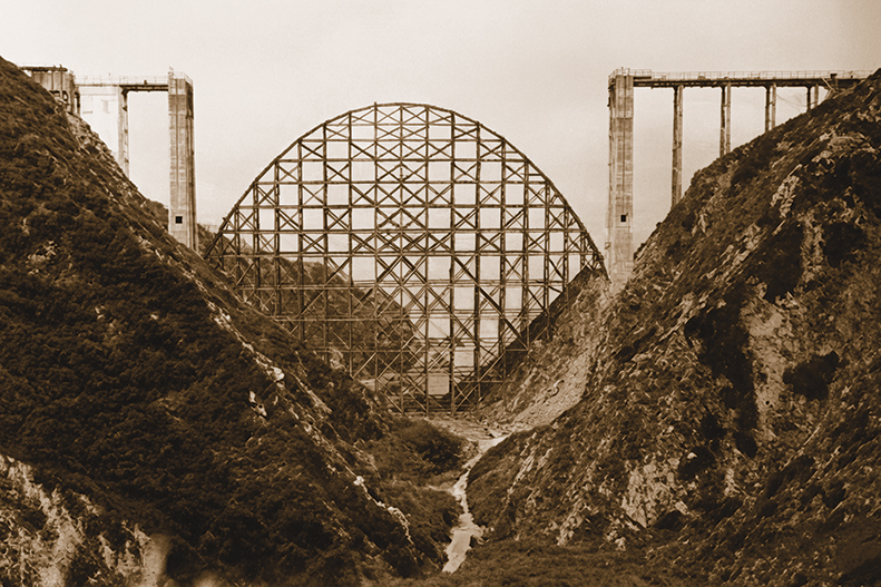
The contract for Bixby Creek Bridge was awarded in August 1931 to Ward Construction Company of San Francisco. Skilled laborers completed the bridge 14 months later on October 15, 1932—an astonishing timeline for such a complex project in such a hostile environment. During construction, work was halted for a month due to severe weather. Construction of falsework for the arch required two months and 300,000 board feet of wood. Formwork (into which concrete was poured) was built on top of the falsework. 45,000 one-pound sacks of cement were used to make the concrete, which was mixed on site. Six hundred thousand pounds of steel was used to reinforce the concrete. Outlines of the forming lumber can still be seen on the concrete surface today. Seven hundred fourteen feet in length and 285 feet above sea level, the cost of the bridge was $203,334.
Bixby Creek Bridge is named for Charles Bixby, the first settler in the canyon. Bixby, a cousin of President James Polk, arrived in Monterey in the 1850s. Soon after arrival he claimed land in the canyon and established a lumber operation and a cattle ranch. He and a partner built a sawmill, and the canyon became known as Mill Creek. Bixby’s operation was long gone when the bridge was built. The bridge itself was originally called Mill Creek Bridge, then Rainbow Bridge, before the name Bixby became attached to both the bridge and the creek.
Between 1998 and 2000, Bixby Creek Bridge underwent extensive seismic retrofitting. The project was complicated by the wise requirement to preserve the historic appearance of the bridge, with the cost of the retrofit reaching $20 million.